
31 Aug
2016
CICES North West host Survey4BIM

The CICES North West region recently hosted a CPD event at their offices in Sale, presented by the cross-industry Survey4Bim group. The speakers were Survey4BIM committee members, Simon Navin (Ordnance Survey) and Mark Lawton (Skanska) who explained the history and reasons behind the group as well as detailing the Big 5 Challenges in achieving BIM… Continue reading
31 Aug
2016
Formby Surveys have invested in UAV technology
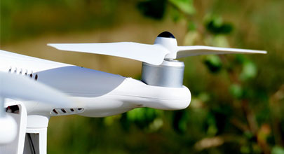
Formby Surveys make continual efforts to stay at the forefront of surveying technology by integrating new equipment that will improve our service offering wherever possible. It’s no secret that, in recent years, UAVs (unmanned aerial vehicles) have become incredibly popular, being adopted by aerial photographers to capture impressive video footage of cityscapes, measuring wildlife in… Continue reading
18 Aug
2016
Could we simplify “Too Much Information”?

If you’ve been on social media in recent months, you may have noticed this short film,” Too Much Information. Too Much Information” was created to help 56 million people gain a deeper understanding of autism and the complications it poses to those who have the condition. Sometimes, autistic people become overloaded by their surroundings, which… Continue reading
17 Aug
2016
Our staff have completed a confined space entry course
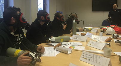
Four members of the Formby Surveys and Geoterra team have completed a two-day confined space entry course to enhance our continually growing range of services. Managing Director, Andy Roberts, Surveyors Jeff Davies and Andy Fellowes from Formby Surveys and our strategic partner and Geoterra Managing Director, Mark Hudson all attended the course to better serve the… Continue reading
29 Jul
2016
We’ve modelled a Pokestop!
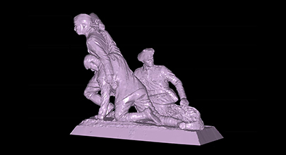
If you hadn’t heard of Pokémon when it first became a worldwide phenomenon in 1995, you’ve surely heard about the recent release of the new app everyone seems to be talking about, Pokémon GO. Pokémon GO is a free-to-play, location-based, augmented reality mobile game, making use of GPS and the camera of compatible mobile… Continue reading