20 Jul
2016
How does the C-ALS® laser scanner improve our subsurface scanning services?
The C-ALS (Cavity Auto-scanning Laser System) is a unique and remarkable specialist surveying instrument that enables the laser scanning of subsurface voids and cavities to be geo-referenced accurately and efficiently.
Working at depths in excess of 50m, the C-ALS system can be applied to a multitude of applications in mining, quarrying, civil engineering and building environments.
Where manned access into voids and cavities is virtually impossible, or deemed too dangerous, the C-ALS can be utilised via borehole or tubular pipe access. Projects that involve collapsed mines, sub-surface shafts and bunkers, underground caverns, and inaccessible roof spaces can all make use of the C-ALS system to provide data that may otherwise be difficult or impossible to obtain by any other method.
Being able to provide geo-referenced datasets without having to physically enter difficult and restricted areas, can significantly minimise risk and improve health and safety procedures, ensuring our surveyors are always in a place of safety when undertaking surveys of this nature.
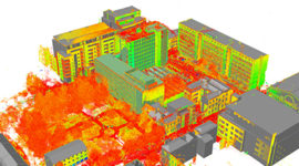
The C-ALS, which is only 50mm in diameter, works by being deployed down (or up!) boreholes. Using the integrated camera, any obstructions can be detected (and avoided) as the scanner head passes through the void. Once the surveyor is satisfied that the C-ALS is clear of any obstructions, the scanner can be activated within the void space. The scanner will produce a geo-referenced 3D point cloud, accurately measuring the shape of the void in full 360° with a range of up to 150m radius.
As soon as the scanner begins surveying the void the 3D point cloud is instantly displayed on the surface laptop via direct hard wired link to the C-ALS. Using the Renishaw Cavity Profiler software, the measurements can be assessed in real time on site, with the point cloud available via several industry standard file formats.
Mark Hudson, Managing Director, Geoterra states, ‘We have been involved with subsurface void surveys for several years on many mining and tunnelling projects. The use of the C-ALS brings huge benefits to our clients, giving certainty as to the size, shape and geo-referenced location of the void relative to surface features and greatly reduces the risk of the unknown as to what lies beneath’.
The strategic partnership between ourselves and Geoterra brings together the latest technology with years of industry experience to enable our clients to significantly benefit from the addition of the C-ALS system to our state of the art and innovative specialist survey equipment fleet.
We’ll be sure to update you with Case Studies as we continue to use the C-ALS on new projects.


