
21 Apr
2016
Formby Surveys’ Scan to BIM Services
Have you heard about Scan to BIM but aren’t really sure what it involves? Well, read on…
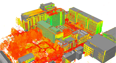
Scan to BIM is a workflow which starts with survey-grade as-built 3D laser scan data (collected using a 3D terrestrial or mobile high definition laser scanner) detailing building structures (internal or external), and infrastructure assets. From the resultant “point cloud” relevant data can then be derived using CAD drafting and 3D modelling techniques to provide, in most cases, a 3D Building Information Model (BIM). This can then be used as a starting point for design teams and asset managers during a design process and beyond.
A Building Information Model can hold all of the spatial (and non-spatial) information that is required to design, construct and maintain a building or infrastructure asset. The information within the model can include a variety of building aspects from materials that are used, to the costs of the build in addition to the fundamental geometry of an asset.
The level of detail in a BIM can (and should!) grow as a project progresses, to reflect the development stages of a project as it’s being constructed, enabling potential issues to be identified and rectified in the early stages of the project, resulting in time and cost savings.
Formby Surveys have a wealth of experience in 3D laser scanning of a large variety of projects and have previously partnered with other companies to deliver BIMs. Recently we have brought that service in-house with the appointment of two Revit® technicians in order to maintain control of the whole process of data collection and model creation.
Our technicians can now deliver the working platforms that our clients require in the form of a working 3D Model that can be utilised immediately.
If you’re interested in learning more about our BIM / Revit® capabilities and what we can do for you, please get in touch as we can provide CPD presentations on the subject if appropriate. We’d love to discuss opportunities with you!


